|
Here is some information I’ve gleaned from the first few pages of the accident report regarding the incident my father was involved in that resulted in the ditching of his plane.
I inquired about receiving a copy of this report after I found a reference to it at Aviation.Archaeology.com. I received this report from Craig Fuller at Aviation Archaeological Investigation and Research, just a few days after I sent the request.
This report was printed from microfiche records and for the most part the report is pretty legible. It is loaded with military abbreviations and has a number of handwritten notes in borders, etc and what may be handwritten corrections or crossed out sections.
The report is typed on “War Department, AAF Form No. 14, Rev. 1, Oct. ’44, Army Air Forces Report of Major Accident”. A note at the top of the first page indicates “RESTRICTED WHEN ENTRIES ARE MADE HEREON”.
There is something like 100 pages in the report. Besides the official AAF Form No. 14 form information there are also statements of the flight crew and the passenger, aircraft flight reports, numerous exhibits, summaries, radio logs, aeronautical charts, and conclusions from various review boards.
The first few pages of this report lists general information about the aircraft involved in the accident, the location, information about the pilot and his flying experience and the personnel involved.
The key parts:
Section A – General Information
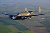
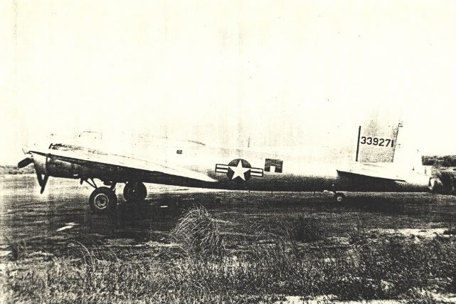
Type, model and series: RB-17G
Place of Accident – State, County, Nearest Town, Distance and Direction From Same: Alibijaban Island, 190 MI, SE of CAFB.
Was Collision With Other Aircraft: No
AF No of Aircraft Involved: #44-83867
Date: 15 Nov 48
Hour and Time Zone: 20:25Z
Section B – Aircraft
Aircraft No: #44-83867
Type Model Series: RB-17 G
Home Station: Clark Air Force Base
Air Force Or Command: FEAF
Subcommand: 13th AF
Wing: 18th Ftr
Group No and Type: 5th Ron
Squadron: 338th Ron
Date of Manufacture: 7 Jul 45
Date Last Overhaul: New
Section C – Operator
[b]Last Name First Name Middle Initial: SMITH PAUL K.
Grade: [/b]1st Lt
[b]Branch: USAF
Sex: [/b]M
Age: 28
Section D– Operators Flying Experience
Total Hours: 2651:25
Hours This Type: 2013:00
Hours This Model: 485:25
Hours Last 90 Days: 84:50
Hours Last 30 Days: 50:25
Hours Last 24 Hours: 16:35
Section E– Personnel Involved:
Capt. Henry L. Choate
Capt. Charles M. Van Dusen
1st. Lt. James C. Loggins
S/Sgt. Chester F. Shans
S/Sgt. Eugene Gregory
S/Sgt. Lyle D. Kirk
S/Sgt. Robert B. Thomas
Maj. Allen C. Forbes
1st. Lt. Waldo N. Blackman
S/Sgt. Boris C. Pepoff
Civilian Passenger Walter S. Sullivan (N.Y. Times Correspondent)
Report Section F: Damage
Damage to aircraft: Major Damage (4 handwritten in)
Damage to engines: 1 - Major Damage (4 handwritten in), 2- Major Damage (4 handwritten in), 3- Major Damage (4 handwritten in), 4- Major Damage (4 handwritten in)
Damage to propeller: 1 - Major Damage (4 handwritten in), 2- Major Damage (4 handwritten in), 3- Major Damage (4 handwritten in), 4- Major Damage (4 handwritten in)
Report Section G – Power Plant Failure
Engine model: R-1820-97 (4, all new)
Engine numbers: SW-044096, SW-045502, SW-043394 and SW- 044662
Engine hours: 188:45, 102:50 120:55 and 226:45 respectfully
Propellers: Hamilton Standard Hydramatic (4, all new) – Note there is a proofreading spelling error mark over this entry. The entry should read Hamilton Standard Hydromatic.
Statement of Engineering Officer, Mechanical and Others as to What Failed and Probable Reason Why: Not a factor.
Octane Rating of Fuel: 100
Report Section H – AIRFRAME, LANDING GEAR, OR OTHER MATERIAL
Determine the Material Failure, Including Statement of Kind of Flight at the Time of Failure: Not a factor.
One of several summaries of the incident:
On 15 November 1948, 1st Lt Paul K Smith, instructor pilot of aircraft RB-17 #83867 gave a thorough emergency procedure briefing to all crew members and passengers before the aircraft departed Port Moresby for Clark Air Force Base via Wewak.
The aircraft landed at Wewak at 0550Z, refueled, and departed Wewak at 0650Z on a heading of 304 degrees with twelve (12) persons and 3,180 gallon of gasoline aboard.
At nightfall the navigator, 1st Lt James C. Loggins, removed his sextant from its case to obtain celestial fixes, but found that the bubble in the sextant was out of order. He attempted to get a bubble in the sextant by normal methods, but could not do so. He examined the bubble chamber and found that all the liquid had leaked out. The navigator also discovered that the fluxgate compass was inoperative, the navigator’s airspeed meter read 15 MPH lower that the pilot’s airspeed indicator, and that the trailing antenna was inoperative. The Loran without a trailing antenna gave very poor reception, so that the navigator had to rely on D.R. He determined his heading b using the predicted winds obtained at Port Moresby. A heading of 311 degrees was used throughout most of the flight. Land recognition was impossible do to a low cloud layer of 6 to 8 tenths stratocumulus.
After approximately seven (7) hours and forty-five (45) minutes out of Wewak, the pilot picked up a weak “A” signal on Manila Range. He continued oh a heading of 311 degrees and at approximately 1630Z he was informed by the navigator that he should be approximately 100 miles from Clark Field. The pilot then informed the navigator that he would fly the range into Clark.
Lt. Smith called Manila Control and informed them that he was approximately 100 miles out and near the south legs of the Manila Range. Manila Control acknowledged the call and cleared the aircraft to Clark Tower for a VFR let-down. However, at this time the pilot had crossed into an “N” quadrant so he corrected to a heading of 356 degrees. He flew into this heading for ten (10) minutes, then correct to a new heading of 40 degrees. He was not sure now which “N” quadrant he was in so after flying twenty (20) minutes he corrected to 45 degrees. He flew this heading for twenty (20) minutes and checked for build or fade. He received no favorable results so he turned to a heading of 25 degrees and checked again for a build or fade. After twenty (20) minutes on a heading of 25 degrees and failing to receive a build or fade, the pilot turned to a new heading of 205 degrees.
At this time the radio operator informed the pilot that he had difficulty getting the HC-3 to give a QDM. So the pilot tried the radio compass to get a null, but static prohibited any good results. The automatic and manual control was inoperative. Lt. Smith then called Manila Control and asked them to contact Clark Field for a QDM.
After flying on a heading of 205 degrees for twenty-five (25) minutes, Manila Control called aircraft #83867 and told them that a QDM had been obtained and for the pilot to steer 136 degrees. The pilot acknowledged the call and also informed Manila Control that he was flying into an “A” quadrant. However, he elected to fly the QDM course of 136 degrees. He flew this course for one hour, then a new QDM of 286 degrees was given by Manila Control at 1940Z.
The aircraft’s gasoline supply was nearly exhausted by this time, and number one engine was feathered due to lack of fuel pressure.
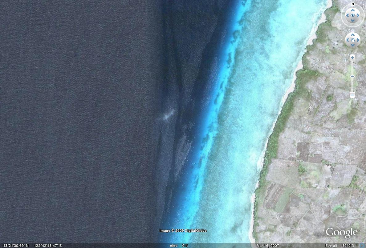
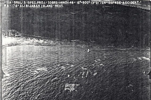
Lt. Smith informed Manila Control that the aircraft would have to be ditched. The pilot prepared the passengers for ditching and then descended through an area of broken clouds. He sighted Alibijaban Island where he ditched the aircraft fifty (50) yards off the northeast shore of the Island at 2025Z, 15 November 1948.
Two of the passengers, Mr. Walter S. Sullivan, Jr. and Staff Sergeant Chester F. Shans, were injured when the plane crashed.
At 0515Z, 16 November 1948, a commercial airliner sighted the aircraft and informed Clark Field by radio. Clark dispatched the necessary aircraft and evacuated the crew and passengers.
Upon consideration of the facts presented during this investigation, the boards find the accident attributed to the following causes:
1. Pilot error 70%
2. Communications personnel error 30%
3. Contributing factors are listed below:
a. Aircraft took off with trailing antenna inoperative
b. Navigator did not pre-flight sextant, before take off of flight.
c. Pilot and navigator airspeed indicator differed by 10 MPH.
d. Pilot failed to perform normal beam recognition procedure
e. Training D.F. station gave pilot erroneous Q.D.M. heading.
f. Pilot did not effect minimum cruise control immediately upon encountering difficulty during range orientation.
g. Communications personnel during the time of the emergency were very inefficient in handling traffic between aircraft and ground.
h. The pilot did not fly out the E.T.A. as determined by the navigator but chose to orient himself on the Manila range before the E.T.A.
So from the first read, it looks like this was not a navigational training flight. Several factors came into play but navigational problems are certainly one of the key reasons for the loss of the plane.
If others are interested, I can continue to post details.
Chester
|


 to this in 3 months:
 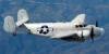 Help us get her all the way back


