AC ID from Google Earth image
Mon Sep 12, 2011 7:31 pm
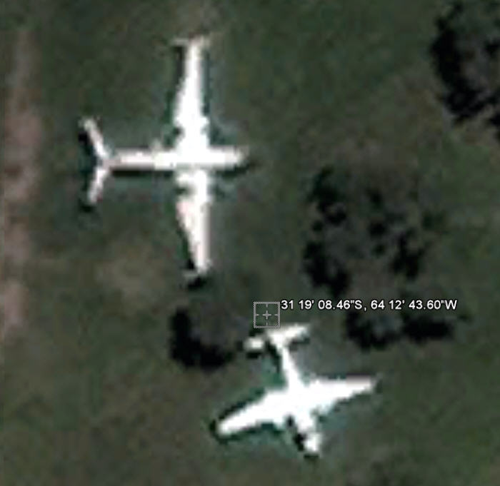
I was forwarded a request to ID the type of aircraft shown in a Google Earth image and frankly, am not sure what it is. The location is the airport at Cordoba, Argentina, and the aircraft in question is the one to the top or north of the image, facing right with a Y-shaped tail. Here is a screen capture but you can also go to the following coordinates, also shown in the image, to see it yourself: 31 19' 08.46S, 64 12' 43.60"W in Google Earth. The aircraft does not look whole to me, even derelict, and the combination of the straight wing and odd Y tail seems slightly familiar but I can't place it, so I hope someone might offer an ID, just 'cause it is bugging me 
Thanks, Randy
P.S. Of course, it will be obvious once someone puts it together, eh? Sorry, no pony or other prizes.

Thanks, Randy
P.S. Of course, it will be obvious once someone puts it together, eh? Sorry, no pony or other prizes.

Re: AC ID from Google Earth image
Mon Sep 12, 2011 7:39 pm
Randy Wilson wrote:I was forwarded a request to ID the type of aircraft shown in a Google Earth image and frankly, am not sure what it is. The location is the airport at Cordoba, Argentina, and the aircraft in question is the one to the top or north of the image, facing right with a Y-shaped tail. Here is a screen capture but you can also go to the following coordinates, also shown in the image, to see it yourself: 31 19' 08.46S, 64 12' 43.60"W in Google Earth. The aircraft does not look whole to me, even derelict, and the combination of the straight wing and odd Y tail seems slightly familiar but I can't place it, so I hope someone might offer an ID, just 'cause it is bugging me
Thanks, Randy
P.S. Of course, it will be obvious once someone puts it together, eh? Sorry, no pony or other prizes.
Piagio Italian Albatross?
Re: AC ID from Google Earth image
Mon Sep 12, 2011 7:48 pm
Take the coordinates "31 19 08.46 S 64 12 43.60 W" and go to here...
 Aerial Visuals - Locator
...and paste the coordinates into the Coordinates field and click on the Search button. It looks like one of them may be an IA-50.
Mike
 Aerial Visuals - Locator
...and paste the coordinates into the Coordinates field and click on the Search button. It looks like one of them may be an IA-50.
Mike
Re: AC ID from Google Earth image
Mon Sep 12, 2011 9:57 pm
The length and wingspan of the upper aircraft seem to fit the IA-50 Guarani II aircraft.
It also had the swept-back horizontal stabilizers and straight wings. These aircraft have been aroung since the late 1960's, so it would not be unusual to see one in a semi-derelict condition.
Walt
It also had the swept-back horizontal stabilizers and straight wings. These aircraft have been aroung since the late 1960's, so it would not be unusual to see one in a semi-derelict condition.
Walt
Re: AC ID from Google Earth image
Mon Sep 12, 2011 10:28 pm
RareBear hit it out of the park. IA-50. Probably cn 28, now the gate guard at the Fuerza Aérea Argentina NCOA.
Or are you asking about the old Aero Commander?
Gary
Or are you asking about the old Aero Commander?
Gary
Re: AC ID from Google Earth image
Mon Sep 12, 2011 11:47 pm
While it may be an IA-50, I note the striking overhead resemblence of it to the IL-18 Beagle with engine pods removed.
Re: AC ID from Google Earth image
Tue Sep 13, 2011 12:27 am
CAPFlyer wrote:While it may be an IA-50, I note the striking overhead resemblence of it to the IL-18 Beagle with engine pods removed.
Save for the assumed size (comparison with what I think is an Aero Commander), I can see your point about the resemblence between the two. I think the lack of glazing/Cockpit placement and location should make it an IA-50.
Re: AC ID from Google Earth image
Tue Sep 13, 2011 2:21 am
Re: AC ID from Google Earth image
Tue Sep 13, 2011 8:01 am
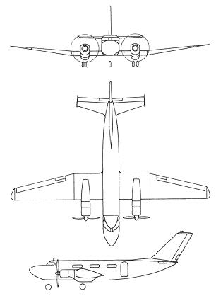
Thanks to everyone for helping to ID the aircraft as an I.A. 50 type, not one I was familiar with. I did find this three-view drawing of the type (http://www.aviastar.org/air/argentina/fma_guarani.php) and just wonder why in the Google image the horizontal tail structure seems different from the drawing. It could be due to the aircraft in the image not being intact. Again thanks. Randy


Re: AC ID from Google Earth image
Tue Sep 13, 2011 8:05 am
The image in Google has much more of a dramatic sweep back on the horizontal stabilizer.
Re: AC ID from Google Earth image
Tue Sep 13, 2011 3:26 pm
Noticed in Tulio's posted photo that you can see the tip tanks, which are also visible in the GE photo. I think the the sweep-back of the horizontal stabilizer in the GE photo is exaggerated due to the angle of the light hitting it.
Walt
Walt
Re: AC ID from Google Earth image
Tue Sep 13, 2011 6:13 pm
Walt - I would tend to agree that it may be an aberation caused by the imaging device itself or perhaps, as you suggest, a sun or light angle issue. While in grad school in Fairbanks, AK a long time ago, I worked on some early imagery from the LandSat/ERTS satellite and saw a number of anomalies due to low sun angles. Those weren't photos but multi-band thermal images however the same kind of thing could happen. Unless someone has a better or more definitive answer, I'm moving on. Thanks.
Randy
Randy