This is the place where the majority of the warbird (aircraft that have survived military service) discussions will take place. Specialized forums may be added in the new future
Post a reply

RCAF WWII questions

Wed Jun 28, 2006 10:33 pm

I am currently going through photos from the collection of a late RNZAF pilot, Ken Law. He trained in NZ and Canada and then flew operationally in the RAF.

In Canada Ken trained at Brandon, Manitoba.

I have some queries for the Canadian forum members here.

Firstly, am i right in thinking this bridge seen in Vancouver is Lion Rock Bridge?
Image

If so, is this on the way into the harbour from the sea?

In a couple of photos there's shots of a group of NZ airmen beside a lage gate with the words Great Divide on them. Is this taken during a stop across the Rocky Mountains by train? If not, where it is?

Image

Also, does anyone know for certain where this railway station is? It's somewhere among the mountains. Is this Banff?
Image

Finally (for now) in Ken's log book a couple of instructors who flew with him in the Cessna Cranes are noted as S/P Sorley, S/P Wiley and S/P Robertson. As S/P is not an Air Force rank, I wondered is this abbreviation for one of the American civil pilots? Was it perhaps a title like Senior Pilot? Any ideas?

Thanks
Dave

Wed Jun 28, 2006 10:40 pm

Hi Dave,
S/P could be a personal abbreviation for Sergeant Pilot... The station could be a challenge - there'd be a lot like that in Canada then, and none now, but the others should be resolvable. I'll do some checking.

Wed Jun 28, 2006 10:56 pm

Firstly, am i right in thinking this bridge seen in Vancouver is Lion Rock Bridge?


Yup it's Vancouver, the bridge is the Lions Gate Bridge and it is heading into the harbour.

Brian....

Train Station

Wed Jun 28, 2006 11:42 pm

Hi Dave

My guess is that if he was training in Manitoba and was on a train trip to the west coast then that station should be Jasper as that's where the trains went throught on the way west.

Hope this helps.

Sincerely Gerry Hagan

Thu Jun 29, 2006 12:46 am

Hi guys,

Thanks for the replies.

Raven, I'm unsure of your theory as all throughout the logbook he has noted Sgt for the sergeant rank on other people, both pilots and otherwise. That's what made me wonder if it were a civil abbreviation maybe.

Brian, thanks for confirming the bridge.

Gerry, the station photo was taken after arriving at Vancouver and heading east to Brandon by train. I will look into the suggestion of Jasper, thanks.

Thu Jun 29, 2006 2:21 am

Dave Homewood wrote:Raven, I'm unsure of your theory as all throughout the logbook he has noted Sgt for the sergeant rank on other people, both pilots and otherwise. That's what made me wonder if it were a civil abbreviation maybe.


I wouldn't dignify it as a 'theory' more a SWAG. ;) If he's used Sgt elsewhere then the theory/SWAG is floating belly up I think!

Vancouver's a complex city-waterfront, it'd be worth having a look at a map to see the layout. Lion Gate Bridge doesn't head into or out of the Harbour IMHO, but across from Vancouver (city) to West Van, which is, naturally, North :roll: of the city! (See http://mc.multimap.com/cs/and_ta_nam//M-5/Y25/M-54840Y25160S200W700H400.gif ). The modern Vancouver Airport is in the South East of this map, and was the RCAF's main Vancouver base in W.W.II, I understand.

Thu Jun 29, 2006 3:24 am

In the military, there are pilots, and then there's everyone else......

My money is on sergeant pilot.....

Thu Jun 29, 2006 11:05 am

Raven wrote:Vancouver's a complex city-waterfront, it'd be worth having a look at a map to see the layout. Lion Gate Bridge doesn't head into or out of the Harbour IMHO, but across from Vancouver (city) to West Van, which is, naturally, North :roll: of the city! (See http://mc.multimap.com/cs/and_ta_nam//M-5/Y25/M-54840Y25160S200W700H400.gif ). The modern Vancouver Airport is in the South East of this map, and was the RCAF's main Vancouver base in W.W.II, I understand.


The only entrance/exit for marine traffic into the Port of Vancouver is under the Lions Gate Bridge.

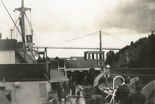
At the point where the ship is in the photo, it would have passed through English Bay and is nearing the Lions Gate Bridge (sometimes called First Narrows) heading east into the inlet. In the photo, Prospect Point (part of Stanley Park) is on the right. Once under the bridge it enters into Burrard Inlet it would have tied up at one of the piers in the port, possibly Ballantyne Pier which has been there since 1923 and is in close proximity to the rail station, but I don't know for sure. As for Burrard Inlet, farther east you can head north up Indian Arm or continue east to Port Moody Arm. Either way you go you eventually hit land.

Google map Vancouver BC and you get a better view of the area, also the Port of Vancouver www.portvancouver.com website has some good photos that show the area.

To keep this in the aviation context, looking out my office window at Burrard Inlet, I spy the following floatplanes, two DeHavilland Beavers, a Twin Otter and a Turbine Otter. :wink:

Dave, do you have any other info on the first photo? Name of the vessel, date?

BTW, regarding Vancouver Airport RCAF/wartime history, there's a good website at http://seaisland1.homestead.com/index.html with some good info.

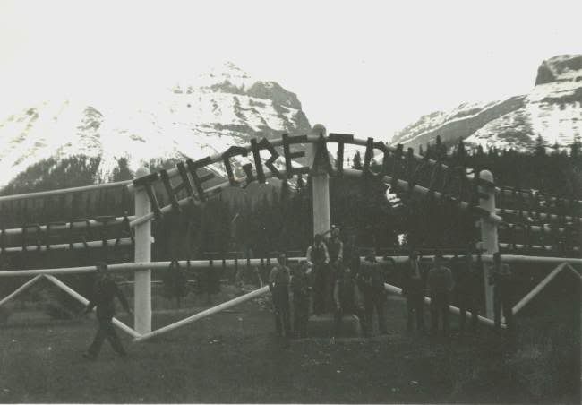
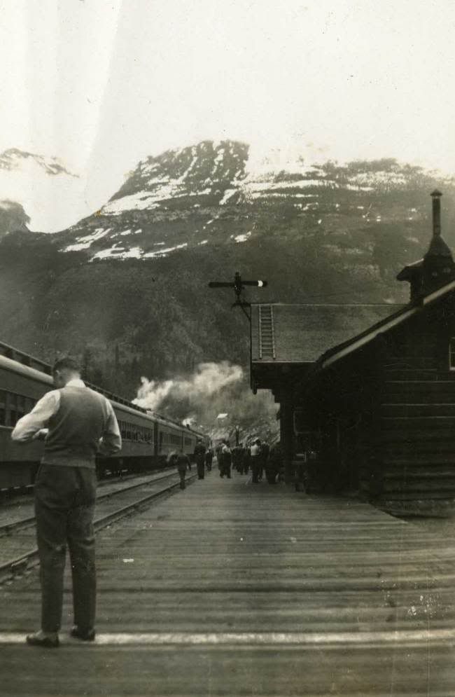
Re: the other photos, I'm pretty sure that The Great Divide photo is near Lake Louise Alberta which is near Banff which leads me to believe the train station may be Banff as well. You may want to contact the West Coast Railway Association, maybe they can ID the location of the train station. Their website is http://www.wcra.org/

BTW, thanks for posting the photos. It's nice to see old pictures from my part of the planet.

HTH

Brian....

Thu Jun 29, 2006 4:13 pm

Thanks BLR,

I'll let you know when I get all the photos sorted and onto Ken's page on my site, as there are loads from Canada. It's a real treasure of a collection.

Yes, the ship was the Awatea, a NZ ship. The date here is mid-late May 1941. I have another photo taken of the same bridge from the other side of the ship too, but with less detail.

I will contact that rail society, thanks.

I'm also sure that the stopover at The Great Divide must have been during that trip east through the Rockies as he never went back, so maybe it is Banff. Perhaps they stopped for a night there, I'm not sure.

Thu Jun 29, 2006 5:46 pm

I find it very interesting that one of the things that make the photos so cool are the people. And I try so hard to get those "people" out.

Just thinking out loud.

Tim

Thu Jun 29, 2006 6:51 pm

BLR wrote:The only entrance/exit for marine traffic into the Port of Vancouver is under the Lions Gate Bridge.

My bad. I was thinking of the road, not the water. Silly me. Apologies for the confusion.

Re: RCAF WWII questions

Thu Jun 29, 2006 8:22 pm

Dave Homewood wrote:Finally (for now) in Ken's log book a couple of instructors who flew with him in the Cessna Cranes are noted as S/P Sorley, S/P Wiley and S/P Robertson. As S/P is not an Air Force rank, I wondered is this abbreviation for one of the American civil pilots? Was it perhaps a title like Senior Pilot? Any ideas?

Thanks
Dave


Hi Dave,

Have you tried asking this question in the forum at rafcommands.com?

There are many RAF and RCAF historians that post there. Also, there is currently a museum at the site of #12 SFTS Brandon, Manitoba, perhaps the volunteers there might have the info you are looking for.

http://www.airmuseum.ca/

I hope this helps!

PS- I'll take a guess and say it stood for Station or Senior Pilot
Last edited by Simcoe Warrior on Thu Jun 29, 2006 8:26 pm, edited 1 time in total.

Fri Jun 30, 2006 9:30 am

I enjoy researching old photos and believe
The Great Divide photo was taken at Kicking Horse Pass on the
Alberta / British Columbia border. Lake Louise is about 7 miles to the east.
The pass connects Banff and Yoho National Parks.

Here's a photo taken from the same spot about 10 years ago.
It's a newer sign but the same message appears to be on it.
The trees are taller but the mountains are the same.

Also note in your old photo the men are gathered around and sitting on a stone
monument. This monument is visible in new photo bottom right.

Bill

Image

Fri Jun 30, 2006 7:05 pm

Brilliant, thanks wls3. With the Lions Gate Bridge and this, that's two out of three positive ID's now.

I have emailed the West Coast Railway Association, about that station, which i increasingly think must be Banff now. I will await their rply. Thanks BLR for the link.

I have also emailed William at the Brandon Museum, a site I was familiar with but had forgotten about. Thanks for the reminder Simcoe. If they don't know, no-one will, as it's their home turf.

Thanks again guys. I've always thought Canada would be a great place to visit, and the more i learn about the RNZAF's connection to the country, the more I want to go. Especially I'd like to visit Brandon, Dunneville and Halifax (the latter where all our men seemed to embark for the UK from), plus of course CWH and a few other museums too. One day...

Cheers
Dave

Fri Jun 30, 2006 8:02 pm

ok here we go since i live in vancouver i can tell you without a doubt that that is lions gate bridge heading into vancouver harbour. the pic is taken from what is called english bay which is on the west side of the bridge. on the east side of the bridge is vancouver harbour. the train station is at banff, alberta. i see the mountain still looks the same. hope this helps. cool pics by the way!!! sim.
Post a reply